-
80 Ijesa IDC Street, Nigeria.
History of IJESA LAND
HISTORY OF UJĘSALAND
In'pęlę o, gbogbo Ujesa ! Se k'ømøde ba ba'tan, He a b'arøba a. Arøba sö'øun ni baba'tan. i.e. exactly in ancestral Ujęsa dialect; whereby 'I ' is replaced with 'U'; except where 'n ' immediately follows it in exceptional cases. Or else, e.g. 'Upęlę ' may replace 'In'pęlę '. NB.
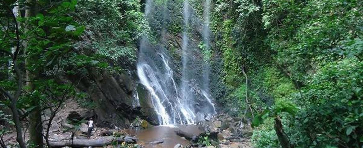
Ujesaland can be found on the longitude 4º75' of the Greenwich and 7º30' latitude North of the Equator. Ujęsaland dwells in the splendour of a very beautiful weather bestowed on her by mother Nature. It lies on the rainforest of the North East of Yorubaland, a very beautiful landscape with hills ranging from 900 feet above sea level in the forest of Øni Valley to around 3000 feet above sea level in Imo Hills and 1800 feet in the hills around Oke-męsi towards the North and about 1,900 feet in Olumirin Waterfalls and others around Ęrin-Ujęsa; forming a boundary with Ęføn-Alaaye and other allies in Ekiti axis and the ancestral Ila/ Igbomina kingdom. Within the beautiful landscape, nature has given Ujęsaland steep inselbergs, which is fertile for timber, and grey igneous rocks, which falls below the red laterite soil and as much annual rainfall, which is always heavy from March to early November; or sometimes into December. It’s always at its peak between June and August as characterically found to be the case in the forest zone, and the forest-bordering Savannah zone of West Africa. Originally, Ujęsaland extends and covers the landmass between Ęnuwa in Ile-Ifę to the borders of Øwø, and the immediate boundary of Øsę river to the East; and had borders with Ila/Igbomina kingdom to the North. As well it has borders with the South-West of present-day Kogi state. As a result of schism occasioned and sponsored by the British colonial powers on the one hand, and the federation and pluralist sphere of interest of Ujęsa people for autonomy, on the other, internal political ambition rivals the extent and span of Ujęsaland; thus reducing it to the present-day size. Ujęsaland came to be reduced to what it is now surrounded by Rivers like Øwęna, and Eti-Øni to the East bordering Ondo State; and rivers Osun and Oora to the West.
UJĘSALAND CULTURE
The major traditional deities unique to the Ujesa people are Ogun, Orisa Onifon, which is prevalent in the North West of Ujesaland. Ogun is very significant and celebrated with grandeur annually by all Ujesas, culminating into the Iwude Festival. Ifa-Orunmila is the knowledge corpus of the Ujęsa people. Ujęsa people used to have very many deeply profound Ifa priests in Yorubaland; far more than often found in other parts of Yorubaland in times past. "Ifa ta l'Øfa, o bere l'øwø ori', is what used to be made used to tease, appellate, and challenge the many itinerant Ujęsa Ifa priests in the few centuries past. One of them, Agbigbagba was prominent Ifa priest in Lagos Island(then called Eko) in the present-day Lagos state. He became an Ifa priest to the then Oba of Lagos, centuries past. He predicted the coming of the Portuguese and other Europeans. He later got married to Ologun Kutere, and to date has been of the major Eko kingship line. Of course, Arampe and Osun are also very important deities in Ujesaland.
UJĘSA FOUNDING FATHERS
Ajibogun Orunaja Agoniyeye Ekun Adimula was the progenitor of the Ujęsa. His memorial statue can be found at the Ulesa city centre. He was also the founder of the Owa Obokun Adimula Monarchical dynasty and that of the ancient, ancestral and modern Ujęsa Kingdom and its monarchy system proficiently inherent till date in the Ujęsa traditional system of government where pluralism, autonomy, and responsible performance system are the rules. Before Hegel's 1830's theory of modern society, I.e., the philosophy of Pluralism came to appear in literal, written form, the Ujęsa people had been using the principle of Pluralism in managing public affairs among themselves. Similarly for other Yoruba or, Karø'ojire people in West Africa especially as, and in matters of multiple religions; and beliefs; our cosmogony. Or, and in cases when having to do with multiple chieftaincy and Obas, without fear of breaking into wars, and social disorders as often found witnessed severally in Europe and the Middle East, many centuries past. And the Ujęsa happened to be the earliest Federaists going by the way Ile-Ifę was managed by Øwa Ajibogun, and successive Öwa Obokun until ceded to be ruled by Ooni; independently, and autonomously. In the very ways the several tributaries of Ujęsaland were allowed to operate as federating entities over the centuries, and in other times following to date, revealing the federal system in Ujęsaland. Of course, it is of such Confederate status and system etched to the nature of administration of Øwa Ajibogun's reign over Ile-Ifę that has continued to prove as the most trenchant test perpetuating and sustaining Ifę-Ujęsa cohesion. Modernity in positive or, negative term may be proving not to allow such cohesion to last these days, or, in the future.
-
Geography
On North East of Yorubaland, 900 feet above sea level in the forest of Øni Valley to around 3000 feet above sea level in Imo Hills and 1800 feet in the hills around Oke-męsi towards the North and about 1,900 feet in Olumirin Waterfalls and others around Ęrin-Ujęsa
-
Location
Ujęsaland is located at approximately longitude 4º75' of the Greenwich and 7º30' latitude North of the Equator.
-
Historical Evolution
Originally extending from Ęnuwa in Ile-Ifę to the borders of Øwø, Ujęsaland had a rich history marked by autonomy and political ambition. However, due to colonial interventions and internal rivalries, its territory was reduced to its present-day size, bordered by rivers Øwęna, Eti-Øni, Osun, and Oora.
-
Cultural and Religious Significance
Ijesa land is home to unique traditional deities such as Ogun, Orisa Onifon, Arampe, and Osun. The Ifa-Orunmila knowledge corpus holds great importance among Ujęsa people, with many renowned Ifa priests in Yorubaland's history. The annual Iwude Festival celebrates Ogun with grandeur